Warehousing logistics
solutions
With the development of e-commerce and express delivery, the pressure on traditional manual
warehousing and logistics is rising. In the environment of economic globalization, rapid development
of IT, and expansive logistics activities, the development and application of innvative information
technologies and intelligent solutions is an important issue that the current warehousing and
logistics industry needs to seriously consider and embrace.

Warehousing
logistics
solutions
With the development of e-commerce and express delivery, the pressure on traditional manual
warehousing and logistics is rising. In the environment of economic globalization, rapid development
of IT, and expansive logistics activities, the development and application of innvative information
technologies and intelligent solutions is an important issue that the current warehousing and
logistics industry needs to seriously consider and embrace.
Solutions
UbiTrack high-precision positioning system adopts
the UWB (Ultra-wideband, nanosecond non-sinusoidal narrow pulses) wireless communication mode
combined with multiple algorithms. Relying on the anchors that are strategically placed in the
warehousing, UbiTrack displays the positioning information of people, vehicles, and things in real
time on the online platform. Thanks to UWB technology and the positioning accuracy of up to 10 cm,
our positioning system helps optimize the logistics operation processes in the warehousing
environment, creating necessary prerequisites for efficient and targeted management of warehousing
operations.
System architecture and principles
UbiTrack positioning system adopts a number of innovative data analysis and
processing algorithms, and a variety of algorithms are hybrid to meet users' different positioning
business needs. It has optional positioning (3D), regional positioning(2D), orbital positioning(1D)
and other positioning modes.Based on the TWR and TDOA positioning algorithms, the location and
surrounding environment information of personnel, vehicles and assets can be accurately located in
real time. At the same time, the system also supports track playback, alarm, data interaction,
camera linkage and other functions.
Single-Sided Two-Way Ranging (SS-TWR): A simple
measurement of the round-trip delay of a single message from one node to node to another, and
sending the response back to the original node. The error in this method of ranging increases with
clock skew, and the error in the time-of-flight estimation increases to the point where the error
makes the estimate very inaccurate.
Double-Sided Two-Way Ranging(DS-TWR):An extension
of Single-Sided Two-Way Ranging (SS-TWR),in which two round-trip time-to-date measurements are used
and combined to obtain time-of-flight. Assuming that devices A and B are 100m apart, the flight time
of electromagnetic waves is 333ns. Because the clock input error is 2033310-9 seconds, resulting in
a ranging error of 2.2mm, it can be ignored. Therefore, bilateral ranging is the most commonly used
ranging method.
Product
Specifications
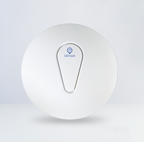
Indoor Anchor
UbiTrack-A1
Suitable for an indoor layout, ceiling and wall installation
mode supported, network cable access supported, POE power supply
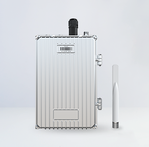
Outdoor Anchor
UbiTrack-A2
Suitable for an outdoor layout, pole installation supported,
waterproof and dustproof, long positioning distance
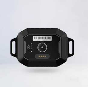
Goods Position Tag
UbiTrack-TG2
Small and lightweight, can be installed in a variety of
ways, can be attached to hard hats or objects
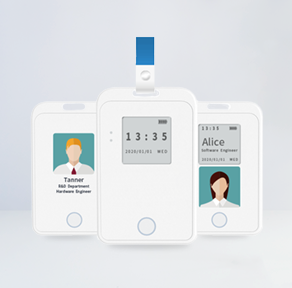
Positioning Badge ll
UbiTrack-TB3
Once the tag is attached, the position of the person or
object can be detected and monitored in real time
Product Specifications

Indoor
Anchor
UbiTrack-A1
Suitable for
an indoor
layout, ceiling and wall installation mode supported, network cable access
supported, POE power
supply

Outdoor
Anchor
UbiTrack-A2
Suitable for
an outdoor
layout, pole installation supported, waterproof and dustproof, long positioning
distance

Goods
Position Tag
UbiTrack-TG2
Small and
lightweight,
can be installed in a variety of ways, can be attached to hard hats or objects

Positioning
Badge ll
UbiTrack-TB3
Once the tag is
attached, the position of the person or object can be detected and monitored in real
time
2D View
The
anchor is set at the four corners of the area and 2.5 meters higher than the tag, which can make it
cover a wider area. The anchor's built-in or external high power and gain omnidirectional antenna,
which transmits data through the RJ45 network cable, can reach a maximum speed of 100–500 Mbit/s,
the response time is only 0.1 ns. The real-time location data of the tag can be visualized, which
allows users to better monitor the position of the tag.
2D View
The anchor
is set at the
four corners of the area and 2.5 meters higher than the tag, which can make it cover a wider area.
The anchor's built-in or external high power and gain omnidirectional antenna, which transmits data
through the RJ45 network cable, can reach a maximum speed of 100–500 Mbit/s, the response time is
only 0.1 ns. The real-time location data of the tag can be visualized, which allows users to better
monitor the position of the tag.
Member Management
The binding and unbinding
of the tag and the member is very convenient, and when binding, you only need to hang the tag to the
Member neck and bind it on the UbiTrack positioning platform, so that the platform can form a unique
identification with the Member until the tag is formed.When unbinding, only the corresponding
unbinding operation needs to be performed on the platform. The binding and unbinding of tags to/from
members makes it convenient to manage.
Member
Management
The binding and unbinding
of the tag and the member is very convenient, and when binding, you only need to hang the tag to the
Member neck and bind it on the UbiTrack positioning platform, so that the platform can form a unique
identification with the Member until the tag is formed.When unbinding, only the corresponding
unbinding operation needs to be performed on the platform. The binding and unbinding of tags to/from
members makes it convenient to manage.
Zone
Management
Importing e-maps allows
users to quickly build indoor maps on the UbiTrack platform and locate them. Maps can be edited on
the UbiTrack platform by adding information and functions. The self-calibration of the anchor can
calibrate the parameters on the anchor floor plan, just follow the instructions to perform the
corresponding operation on the UbiTrack platform, and the system will automatically identify the
position parameters of the anchor and perform calibration.
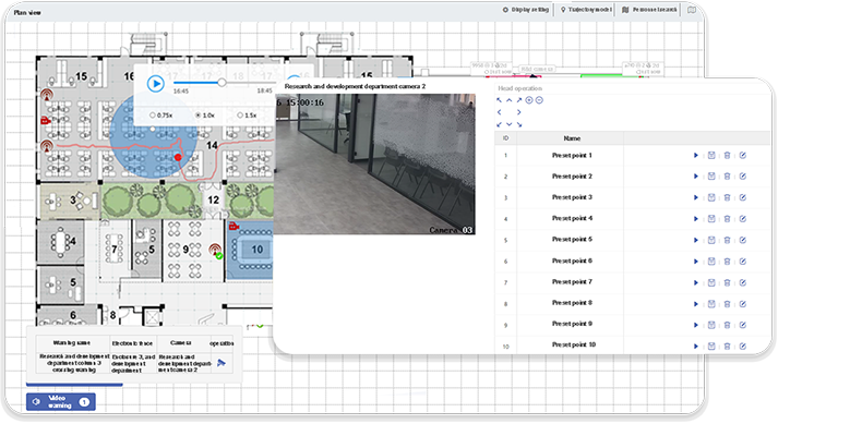
Track
Mode
The UbiTrack platform
provides multiple ways, including time-based, location-based, tag-based, and attribute-based
querying. Users can view historical position data of moving objects in real time and perform
retrospective analysis. At the same time, the track function also allows users to trace the
historical trajectory of moving objects; the UbiTrack platform provides track mode to help users
intuitively understand the motion status and path of moving objects.
Use left/right arrows to navigate the slideshow or swipe left/right if using a mobile device


 UbiTrack Partner
Solutions
UbiTrack Partner
Solutions

 UbiTrack Software Grading
Services
UbiTrack Software Grading
Services

